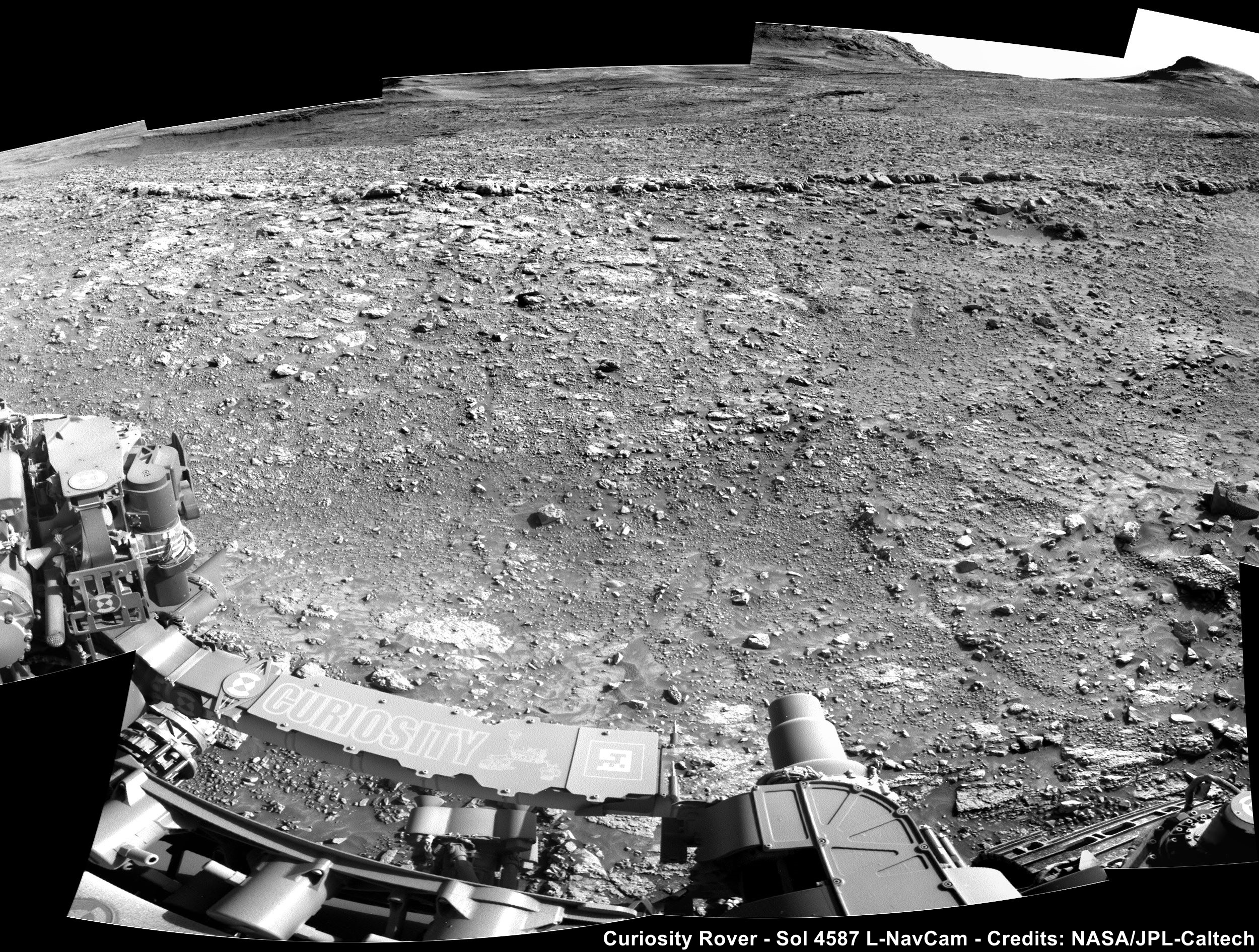
1
6
4273-4274 Blog (lemmy.world)

Prep Rally - Curiosity Rover Blog for Sols 4273-4274

Earth planning date: Monday, Aug. 12, 2024

The SAM EGA over the weekend was successful, and that means we’re well on our way to planning the GCMS (Gas Chromatograph Mass Spectrometry) on our “Kings Canyon” drill sample! GCMS is an energy-intensive activity, so we’ll be using today’s two-sol plan mainly for recharging our battery and prepping SAM by cleaning its GC column with high temperatures (like you’d clean your own oven!). We can still afford about 75 minutes of remote sensing over both sols this plan and are using it for our usual ChemCam, Mastcam, and Navcam activities.

On the first sol, ChemCam is kicking things off with a LIBS (Laser Induced Breakdown Spectrometer) on “The Major General” — some crunchy light-toned bedrock about 9 feet away (about 2.8 meters) — then will capture a long-distance 10-frame RMI of the Gediz Vallis channel floor to the south. Mastcam finishes off the first sol’s 72-minute science block with an M100 image of The Major General LIBS spots and a 68-frame stereo mosaic of the midfield terrain to fill in what’s left of the midfield with M100. We’ll nap until about 15:15 local Mars time, when we'll wake back up to take just two M100 images near the RSM hardstop at the same timing as a previous mosaic to make sure we have continuous coverage across the hardstop. SAM’s GC column clean is planned between 21:00 and 01:00; overnight between our two sols.

On the second sol, we’ll have our second remote sensing block around 11:00 for 73 minutes. ChemCam is planning a second LIBS target on “Dewey Point” — a slab of light-toned bedrock about 13 feet away (about 3.9 meters) — a passive-spectrum observation of a dark float block named “Waller Minaret,” and another long-distance four-frame RMI of southern Kukenan butte to the southeast. Mastcam has just a single M100 image of Dewey Point’s LIBS spots this sol so that Navcam can complete some environmental movies to hopefully capture some dust devils and maybe even some clouds!

Written by Natalie Moore, Mission Operations Specialist at Malin Space Science Systems

Source for this blog and the archive of all blogs (with all the links and the original raw images etc) : https://science.nasa.gov/blogs/sols-4273-4274-prep-rally/

These blog updates are provided by self-selected Mars Science Laboratory mission team members who love to share what Curiosity is doing with the public.

Dates of planned rover activities described in these reports are subject to change due to a variety of factors related to the Martian environment, communication relays and rover status.

Image credits: NASA/JPL-Caltech/MSSS

2
19
4270-4272 Blog (lemmy.world)

Sample for SAM - Curiosity Rover Blog for Sols 4270-4272

Earth planning date: Friday, Aug. 9, 2024

The focus for this three-sol weekend plan is delivering a portion of the Kings Canyon drill sample to SAM for Evolved Gas Analysis (EGA), following on from a successful CheMin analysis. The CheMin and SAM analyses, coupled with APXS and ChemCam analyses, will tell us about the composition and mineralogy of this block within the Gediz Vallis channel deposit. We can compare it to the composition and mineralogy of the intriguing Mammoth Lakes drilled sample at Whitebark Pass, which was near the elemental sulfur blocks, and also within the Gediz Vallis deposit, as well as to the bedrock outside the channel and other previous drilled samples. This will help inform the source(s) of the blocks, which could be derived from higher up on Mount Sharp.

To further characterize the Kings Canyon block and immediate vicinity, we will acquire three ChemCam LIBS analyses. The “Gabbot Pass” target is on the same light-toned rock as the drill target. “New Army Pass” will investigate the edge of the drilled block, which exhibits textural and tonal similarities to an interesting previous APXS target, “Discovery Pinnacle.” Finally, “Bridalveil Falls” is on a freshly broken, bright rock on the edge of the drilled block. Mastcam will provide documentation imaging of the three targets.

Looking further afield, we continue to image the stunning scenery surrounding us from this vantage point. We planned a ChemCam long distance remote imager (LD RMI) mosaic of the Gediz Vallis channel form to the south, and an extension of a Mastcam mosaic of the Milestone Peak area of the deposit. These mosaics will help us to further characterize the Gediz Vallis deposits, and hopefully the processes responsible for their emplacement (e.g., debris flow or rock avalanche). We will also acquire a Mastcam mosaic of the Texoli butte, which represents a cross section of the rock layers that we will eventually drive over when we leave the Gediz Vallis deposit and continue climbing Mount Sharp.

It isn’t just about the rocks though! The environmental and atmospheric science team also have several observations in this plan to monitor changes in the atmosphere. These include Mastcam tau and Navcam line of sight observations, as well as Navcam zenith, suprahorizon and dust devil movies. Standard DAN, RAD and REMS activities round out the plan.

Written by Lucy Thompson, Planetary Geologist at University of New Brunswick.

Source for this blog (with all the links and the original raw image): https://science.nasa.gov/blogs/sols-4270-4272-sample-for-sam/

These blog updates are provided by self-selected Mars Science Laboratory mission team members who love to share what Curiosity is doing with the public.

Dates of planned rover activities described in these reports are subject to change due to a variety of factors related to the Martian environment, communication relays and rover status.

Image credits: NASA/JPL-Caltech/MSSS

3
14

I've no idea what the correct name would be, but could this a debris conglomerate? NASA/JPL-Caltech/MSSS/fredk

4
16

Curiosity is capturing some stunning views looking down the mountain towards the crater floor. Here are three overlapping de-Bayered R-MastCam images that are from a larger set awaiting downlink from the rover. These were captured on sol 4265. Credits: NASA/JPL-Caltech/MSSS/fredk

5
26

ChemCam RMI of the 1.6 cm diameter drilled hole. Waiting for a mission update to tell us if enough sample was obtained...

6
13

R-MastCam mosaic (de-Bayered) assembled from 3 overlapping mast camera (R-MastCam) frame. Assembled in MS-ICE - Credits: NASA/JPL-Caltech/MSSS/fredk

7
6

Team members at NASA's Jet Propulsion Laboratory share the challenges of the Curiosity Mars rover's final minutes to landing on the surface of Mars.

8
14

A Royal Birthday Celebration at Kings Canyon - Curiosity Rover Blog for Sols 4263-4265

Earth planning date: Friday, Aug. 2, 2024

Prepare your party poppers, horns, and confetti! On Aug. 6 (EDT), after 4,265 Martian sols since Curiosity first landed in Gale Crater, the rover will be turning 12 years old. I still remember the excitement of watching Curiosity's landing back when I started high school. Now, as a "Keeper of the Plan" for the Geology and Mineralogy theme group, I have the incredible opportunity to be part of this mission. To mark the end of the 12th year, Curiosity is currently parked within a large valley called Gediz Vallis, all primed and ready to drill "Kings Canyon" (pictured).

The previous plan involved conducting a preload test in Drill Sol 1, to ensure we could drill safely. The test was successful, confirming that Kings Canyon is safe to drill! The team was also happy with the chemical composition data from the APXS (Alpha Particle X-ray Spectrometer) results, so we are all set to drill a new king!

On the first sol, we’ll conduct Drill Sols 2 and 3, where the actual drilling will take place and the drilled material will be subsequently characterized. Alongside drilling, we also plan to capture a MAHLI (Mars Hand Lens Imager) image of a relatively peaceful target called “RAGE.” (This target is the site where the rover will later perform the RAGE activity to clean up after drilling.) On the second sol, we’ll perform a LIBS (Laser Induced Breakdown Spectrometer) analysis on "Lake Eleanor," a rock crushed by Curiosity’s wheel, revealing light-toned material. Additionally, we will conduct a ChemCam passive observation on a section of the Gediz Vallis channel floor.

The third sol is packed with scientific activities. We’ll conduct a LIBS on "Lyell Glacier," a rock with different colored coatings to compare with dark-toned coatings seen by the Perseverance rover. ChemCam will take the opportunity to capture a long-distance Remote Micro-Imager (RMI) shot of an arm of “Milestone Peak,” which is full of gray rocks aligned in a slightly different direction from the rest of the ridge within the center of Gediz Vallis. We also plan to capture four Mastcam mosaics: one of the southern section of a large hill called “Kukenan” and three mosaics documenting the different textures, structures, and lithologies of the deposits within the valley floor. Furthermore, a ChemCam Passive Sky observation and atmospheric monitoring activities in the morning are also on the agenda.

As we prepare for these exciting activities, the anticipation builds for Curiosity’s 12th birthday. Here's to many more years of exploration and discovery on the Red Planet!

Written by Amelie Roberts, Ph.D. candidate at Imperial College London

Source for this blog (with all the links and the original raw image): https://science.nasa.gov/blogs/sols-4263-4265-a-royal-birthday-celebration-at-kings-canyon/

These blog updates are provided by self-selected Mars Science Laboratory mission team members who love to share what Curiosity is doing with the public.

Dates of planned rover activities described in these reports are subject to change due to a variety of factors related to the Martian environment, communication relays and rover status.

Image credits: NASA/JPL-Caltech

9
35

As we close in on Curiosity's 'landiversary' I feel it is a good time to share one of my favourite images from its mission inside Gale crater. This mid-afternoon view from the right-side Mast Camera (R-MastCam) on Curiosity rover features a distant section of the inner rim wall of Gale Crater. It was acquired during a period when there was little dust or haze in the atmosphere, so conditions were good for long-distance imaging. JPL have been studying this particular section of the rim wall throughout the mission comparing the differing lighting conditions. The rover acquired this image during mission sol 1309, April 16, 2016, while the rover was conducting remote science in-between drives on the "Naukluft Plateau" on lower Mount Sharp. The tall peak of the crater wall featured in this image, was located at azimuth 357.2 degrees east of north (or 2.8 degrees from north), is about 17.6 miles (28.4 kilometers) away from the rover at that time. The rim rises about 3,900 feet (1,200 meters) above the base of its foothills. Credits: NASA/JPL-Caltech/MSSS

10
15

Kings Canyon Go Again! - Curiosity Rover Blog for Sols 4259-4260

Earth planning date: Monday, July 29, 2024

Our weekend drill preload test on the target “Kings Canyon” (shown in the accompanying MAHLI image) didn’t give us the full range of data we need to move forward with the full drilling process. This coming Wednesday, we hope to rerun our preload test on Kings Canyon or somewhere very similar on the same bedrock, and to get APXS and ChemCam analyses in order to determine scientific suitability for drilling. As a result, this plan focused on getting the arm ready to fulfill those diagnostic activities, described by our Science Operations Team Chief Elena in last Friday’s blog.

In the meantime, we are in such an interesting area that we have a very long liens list (our wish list). Our problem today and probably for the foreseeable future will be a good one - trying to keep below our upper limits on how much of that wish list we are going to try to get in on a given day!

We have recently seen examples of bedrock slabs or outcrops with a flat, paler toned centre and a rim of darker, greyer material which surrounds the main slab. We saw this about 50 sols ago at the Mammoth Lakes drill site and we see it here too. The relationships between the centre of the slab and the rim are very intriguing and we are keen to understand the interplay between the two textures. Mastcam will take two large mosaics in this area. “Sam Mack Meadow” is a 7x4 mosaic (i.e., 4 rows of 7 images) on an area of crushed grey material, and “Merced Grove” is a 7x6 mosaic on more intact rim material. ChemCam have also planned a LIBS analysis of Merced Grove and one at “Clinch Pass” in the centre of the block. Together these activities will help us to look at relationships here and to compare with previous examples, such as at the Mammoth Lakes drill site.

ChemCam will acquire a passive measurement on “Wilts Col,” a small dark toned float rock about 4 metres away from the rover as part of a continuing campaign to assess the nature of the floats (loose rocks) which are strewn around this part of the crater. ChemCam will also acquire 2 RMI (long distance images) 10x1 mosaics, looking at the stratigraphy and layering of the distant hills – getting a head start on the science assessment before we even get close!

The atmosphere and environment science theme group (ENV) also crammed their section of the plan full of activities. Since landing (almost 12 years ago now!!), the ENV group has been reporting on environmental conditions in Gale, and this plan was no exception. We have some regular DAN passives, REMS activities and a Navcam dust devil movie, and a single Mastcam “Tau” measurement, which looks at dust in the atmosphere.

Written by Catherine O'Connell-Cooper, Planetary Geologist at University of New Brunswick

Source for this blog (with all the links and the original raw image): https://science.nasa.gov/blogs/sols-4259-4260-kings-canyon-go-again/

These blog updates are provided by self-selected Mars Science Laboratory mission team members who love to share what Curiosity is doing with the public.

Dates of planned rover activities described in these reports are subject to change due to a variety of factors related to the Martian environment, communication relays and rover status.

Image credits: NASA/JPL-Caltech/MSSS

11
15

A Little Nudge on Kings Canyon - Curiosity Rover Blog for Sols 4257-4258

Earth planning date: Friday, July 26, 2024

Today’s 2-sol weekend plan is our first taste of a new location for a potential sampling campaign. We call today’s plan type: Drill Sol 1 - triage contact science.

We arrived this morning to a lovely new workspace. The science team has been eagerly observing these lighter-toned rocks first from orbital data, then from our drive direction imaging as we approached them, and now they are right in front of us! Because the science team had been contemplating the possibility of sampling these rocks, the drive that we planned on Wednesday ended in just the right orientation in case the team does decide to drill here. Variables that matter are the rover roll and pitch – so that we can both drill the rock safely but also then deliver sample to our two internal instruments, CheMin and SAM. Additionally, the rover heading needs to be just right so that we can communicate clearly with Earth – perhaps for several weeks if we remain for a campaign! We have specially certified Rover Planners called Sampling Campaign Rover Planners (SCaRPs) and they go into action on Drill Sol 1 to confirm that all those special considerations for drilling are met including finding the actual target on the ground that we want to assess.

This morning, the SCaRPs swiftly found a great target and we named it “Kings Canyon.” Kings Canyon National Park is in the southern Sierra Nevada range in California. Kings Canyon itself is a glacially carved canyon more than a mile deep! The national park also contains some of the world’s largest stands of Giant Sequoia trees.

The Drill Sol 1 plan has two purposes – first to determine if our target, Kings Canyon, meets the science teams criteria for sampling – for example, is it compositionally interesting? The second objective is to determine if the rock and specific target, are safe to drill; can it handle the forces from the drill, for example. We call this activity a “drill preload test.” Therefore, the primary activities in today’s plan are the preload test and contact science on Kings Canyon – we will first brush the target to remove surface dust and then take close-up imaging with our MAHLI instrument and compositional data with our APXS instrument.

In anticipation of a notional full drill on Monday, today’s team was very conservative with the amount of power we used. This meant limiting our remote sensing observations to only those that the team thought were most important to get down timely to support a drill campaign. We’ll use our ChemCam instrument to also study Kings Canyon, ChemCam provides complementary compositional data to the APXS observations. Together these observations will help inform the science about whether they want to proceed with sampling. Today’s plan also includes our typical environmental monitoring observations that we take at a regular cadence.

Hope your weekend is as busy and fun as Curiosity’s!

Written by Elena Amador-French, Science Operations Coordinator at NASA's Jet Propulsion Laboratory

Source for this blog (with all the links and the original raw image): https://science.nasa.gov/blogs/sols-4257-4258-a-little-nudge-on-kings-canyon/

The previous blog for Sols 4255-4256 (publication delayed) https://science.nasa.gov/blogs/sols-4255-4256-just-passing-through/

These blog updates are provided by self-selected Mars Science Laboratory mission team members who love to share what Curiosity is doing with the public.

Dates of planned rover activities described in these reports are subject to change due to a variety of factors related to the Martian environment, communication relays and rover status.

Image credits: NASA/JPL-Caltech (PH)

12
13
submitted 2 weeks ago* (last edited 2 weeks ago) by paulhammond5155@lemmy.world to c/curiosityrover@lemmy.world

Assembled from 15 overlapping Bayer reconstructed left-side mast camera images. Assembled in MS-ICE - Credits: NASA/JPL-Caltech/MSSS/fredk

13
21
submitted 3 weeks ago* (last edited 3 weeks ago) by paulhammond5155@lemmy.world to c/curiosityrover@lemmy.world

Pit Stop for Contact Science - Curiosity Rover Blog for Sols 4253-4254

Earth planning date: Monday, July 22, 2024

Last week we wrapped up activities at Fairview Dome and started heading south towards our next potential drill location in the Upper Gediz Vallis ridge campaign. We had about a 29-meter (about 95 feet) drive over the weekend, which set us up nicely for contact science and remote sensing today.

Today’s two-sol plan includes APXS and MAHLI on a gray rock named “Discovery Pinnacle” to assess variations in bedrock chemistry and compare it to what we have seen recently. We also planned ChemCam LIBS on “Miguel Meadow” to evaluate the typical bedrock in our workspace, as seen in the above image from the front Hazcam. The plan also includes a Mastcam mosaic covering the large patch of light-toned rocks in front of the rover to look for variations in lithology. Two ChemCam long-distance RMIs are also planned to evaluate the stratigraphy exposed by a channel cut into the Gediz Vallis ridge deposit, and to look more closely at a well-laminated dark-toned boulder on the channel floor. Then Curiosity will drive about 16 meters (about 52 feet) farther south, and will take post-drive imaging to help us evaluate another patch of light-toned bedrock in the next plan.

In addition to targeted remote sensing, today’s plan includes observations of atmospheric opacity, searching for dust devils, an autonomously selected ChemCam AEGIS target, and standard DAN and REMS activities.

We’re all curious to see what Wednesday’s workspace will hold as we start thinking about the next place to drill! Meanwhile, much of the science team is gathered in Pasadena, California, this week at the Tenth International Conference on Mars, sharing lots of exciting results from the mission thus far. Looking forward to what comes next!

Written by Lauren Edgar, Planetary Geologist at USGS Astrogeology Science Center

Source (with all the links and the original raw image): https://science.nasa.gov/blogs/sols-4253-4254-pit-stop-for-contact-science/

These blog updates are provided by self-selected Mars Science Laboratory mission team members who love to share what Curiosity is doing with the public.

Dates of planned rover activities described in these reports are subject to change due to a variety of factors related to the Martian environment, communication relays and rover status.

Image credits: NASA/JPL-Caltech/MSSS

edit - corrected typo in title

14
28
4248 - R-MastCam (lemmy.world)

NASA/JPL-Caltech/MSSS/fredk

15
15

Curiosity Rover - Sol 4244 - Focus-stacked MAHLI mosaic (4x1), acquired from a camera standoff distance of 25 centimeters (about 10 inches) featuring the edges of 'Wishbone Lake'. For scale the mosaic width is about 36.4 cm (14.3 inches), and is centered on the 'Arrowhead Spire' pebble. Image Credits: NASA/JPL-Caltech/MSSS

16
23

The link contain a great write up on the Elemental Sulfur rocks investigated by the rover. There are 360 videos and images as well as the text

17
16

MAHLI image: Scene width ~4 cm (1.57")

18
10

We Can’t Go Around It…We’ve Got To Go Through It!’ - Curiosity Rover Blog for Sols 4241–4242.

Earth planning date: Wednesday, July 10, 2024

Curiosity is currently trekking across Gediz Vallis channel because, as my nephew’s favorite book says, if we can’t go around it... we’ve got to go through it! Recently we’ve been parked for a while on the channel to drill “Mammoth Lakes,” and are now on the move once again exploring the rubbly rocks. Today the science team planned two sols of activity for Curiosity as we venture on through and across Gediz Vallis channel.

On the first sol we undertake nearly two hours of planned science. This includes Navcam deck monitoring and a Mastcam tau, to measure dust in the atmosphere as part of our atmospheric and environmental activities, alongside some geology-focused observations. MAHLI is taking a close up image of “Donohue Pass” that we targeted with ChemCam LIBS and Mastcam imagery in the previous plan. ChemCam will take a LIBS on a rock named “Negit Island” that caught the team’s eye with a lighter base and a darker upper section. ChemCam will also take two RMIs of Gediz Vallis, one to document the wall of Gediz Vallis channel that we can see up ahead of us, and one looking at the rocks that sit within the channel. Mastcam is also taking a look at the wall of Gediz Vallis, as well as continuing a mega-mosaic started in the last plan that took 54 images of “Stubblefield Canyon.” Today we planned another 48 images to document the rest of this area named “Echo Ridge.”

ChemCam will take a passive observation of an interesting rubbly target in this region called “Wishbone Lake,” prior to a five-meter drive (about 16 feet) over to this feature. Once we have arrived, Curiosity will take some post-drive Navcam imaging and a MARDI image of our left-front wheel. After a well-deserved sleep, on the second sol of this plan Curiosity will automatically choose a LIBS target in our new workspace, before taking a dust-devil and suprahorizon movie to round off this plan.

Written by Emma Harris, Graduate Student at the Natural History Museum, London

Source (with all the links and the original raw image): https://science.nasa.gov/blogs/sols-4241-4242-we-cant-go-around-itweve-got-to-go-through-it/

These blog updates are provided by self-selected Mars Science Laboratory mission team members who love to share what Curiosity is doing with the public.

Dates of planned rover activities described in these reports are subject to change due to a variety of factors related to the Martian environment, communication relays and rover status.

Image credits: NASA/JPL-Caltech

19
14
20
13
4239 - R-MastCam (lemmy.world)

de-Bayered R-MastCam of a small rock just beyond the reach of the rover's robotic arm NASA/JPL-Caltech/MSSS/fredk

21
18
4239-4240 - Blog (lemmy.world)

‘Vuggin’ Out’ - Curiosity Rover Blog for Sols4239-4240.

Earth planning date: Monday, July 8, 2024

And just like we planned, Curiosity successfully drove about 11 meters (about 36 feet) after a 27-sol drill campaign at Mammoth Lakes! Not so fast, though, these rocks are just too interesting to leave behind so quickly. Instead of high-tailing it uphill like we usually do after a drill campaign, we’re staying put for another plan to get as much contact science on these diversely-toned rocks with mysterious origins and vugs (geologic term for the cavities in the rock) galore. It’s been a high priority to get as much color documentation of the clasts in the area, so a plan like this has kept my team busy commanding the Mastcams!

The first sol of this plan includes a long, 90-minute remote science block including about 50 minutes of ChemCam LIBS and RMI, about 32 minutes of Mastcam images, and a six-minute dust devil movie taken by Navcam. ChemCam is using its one-LIBS-per-sol on a conglomeratic block target named “Mount Baxter,” and an RMI of Echo Ridge to the south. Mastcam is taking a 12-image mosaic of Mount Baxter after the LIBS work is done, and a huge 54-image mosaic to the east of Echo Ridge called “Stubblefield Canyon.” After the mast instruments are done, our rover will take about a four-hour long nap and wake up to unstow our arm. Arm activities this plan include two vug-tastic targets named “Lake Dorothy” and “Palisade Glacier,” both imaged by MAHLI and investigated by APXS. Curiosity is back to sleep by about 22:50, which sounds like my perfect sleep schedule.

The second sol of this plan includes a 60-minute remote science block containing about 45 minutes of ChemCam LIBS and RMI, only about six minutes of Mastcam images, and a whopping two hours of dust devil and environmental monitoring by Navcam. With 27 sols at our last location, we noticed significant wind motion between repeated images, and Navcam monitoring helps us keep track of how windy it is. Our rover will take another midday nap and wake up in the evening for a bonus APXS integration on Lake Dorothy, helping raise the signal-to-noise ratio and uncover more secrets (and questions) these Martian rocks have been keeping for millions of years.

Written by Natalie Moore, Mission Operations Specialist at Malin Space Science Systems

Source (with all the links and the original raw image): https://science.nasa.gov/blogs/sols-4239-4240-vuggin-out/

These blog updates are provided by self-selected Mars Science Laboratory mission team members who love to share what Curiosity is doing with the public.

Dates of planned rover activities described in these reports are subject to change due to a variety of factors related to the Martian environment, communication relays and rover status.

Image credits: NASA/JPL-Caltech/MSSS

22
15

MAHLI camera. NASA/JPL-Caltech/MSSS

23
35
submitted 1 month ago* (last edited 1 month ago) by paulhammond5155@lemmy.world to c/curiosityrover@lemmy.world

Curiosity acquired this image using its Mars Hand Lens Imager (MAHLI), located on the turret at the end of the rover's robotic arm, on July 6, 2024, Sol 4236 at 23:46:27 UTC.

The image features an after dark view of the Mammoth Lakes 2 drill fines and drill hole, it was taken from a standoff distance of about 10 centimeters (~4 inches) above the surface. For scale, the diameter of the drilled hole is 1.6 centimeters (0.63 inches)

Most images acquired by MAHLI in daylight use the sun as an illumination source. However, in some cases, MAHLI's two groups of white light LEDs and one group of longwave ultraviolet (UV) LEDs might be used to illuminate targets. When Curiosity acquired this after sunset image, the camera group 1 white light LEDs were on, the group 2 white light LEDs were also on, and the ultraviolet (UV) LEDS were off.

Note the neat vertical array of ChemCam laser strikes on the side wall of the drilled hole. The laser is used to obtain spectra providing information about Chemical composition of the substrate of the drilled rock.

Image credit: NASA/JPL-Caltech/MSSS

24
10

One More Time… for Contact Science at Mammoth Lakes - Curiosity Rover Blog for Sols 4236-4238.

Earth planning date: Friday, July 5, 2024

Curiosity will drive away from the Mammoth Lakes drill location on the second sol of this three-sol weekend plan, but before she does, the team will take the opportunity for one last chance at contact science in this interesting region of the Gediz Vallis deposit. The team have noticed distinct troughs surrounding many of the bright-toned, pitted blocks in this area and have been wanting to get closer imaging with MAHLI before driving away. We were unable to do this with powdered Mammoth Lakes still in the drill stem but, having dumped any remaining material in the previous plan, Curiosity is free to use her arm again for contact science, and hence the MAHLI camera. We will take images from about 30 centimeters (about 12 inches) away from the block (“Glacier Notch”) with MAHLI. Unfortunately, “Glacier Notch” was too close to the rover to be able to fit the turret in for APXS to examine the chemistry, so we had to choose a different target: “Lake Ediza” is an example of gray material that rims the Mammoth Lakes drill block.

We also have one last chance for ChemCam and Mastcam in this immediate area. We will acquire ChemCam passive spectra of the Mammoth Lakes powdered material surrounding the drill hole (we collected APXS data and MAHLI images of the drill fines in the previous plan) and LIBS on a darker-toned target, “Zumwalt Meadow.” These targets will be documented by Mastcam. The long-distance imaging capabilities of ChemCam will also be utilized to examine nearby ridge and trough-like forms.

There are also a slew of atmospheric/environmental observations planned. Before we drive away, we will take advantage of being parked in the same spot while drilling to monitor any changes in the immediate environment by re-imaging a couple of areas previously captured on multiple occasions by Mastcam. Other atmospheric observations include a Navcam line-of-sight mosaic, Navcam dust devil, zenith, and suprahorizon movies, a ChemCam passive sky, and Mastcam taus.

After the drive, MARDI will image the terrain beneath the wheels and ChemCam will autonomously select a target to analyze with LIBS. Standard REMS, DAN and RAD activities round out the plan.

The team are looking forward to a new workspace when we return for planning on Monday, and continued investigation of the Gediz Vallis deposit.

Written by Lucy Thompson, Planetary Geologist at University of New Brunswick

Source (with all the links and the original raw image): https://science.nasa.gov/blogs/sols-4236-4238-one-more-time-for-contact-science-at-mammoth-lakes/

These blog updates are provided by self-selected Mars Science Laboratory mission team members who love to share what Curiosity is doing with the public.

Dates of planned rover activities described in these reports are subject to change due to a variety of factors related to the Martian environment, communication relays and rover status.

Image credits: NASA/JPL-Caltech/MSSS

25
25

And That’s (Nearly) a Wrap on Mammoth Lakes! - Curiosity Rover Blog for Sols 4234-4235.

Earth Planning Date: Wednesday, July 3, 2024

We received the data from our SAM analysis of the Mammoth Lakes sample late Monday afternoon. After chewing over the results, the team declared we are very happy with all of the analyses we’ve done with this sample, and we are ready to move on to greener pastures… er, redder rocks! This decision means that we will go ahead and clear out the drill assembly in today’s plan, and subsequently use the arm to collect MAHLI and APXS observations of the pile of drill tailings around the drill hole.

We’ll also have some time for remote sensing activities that use our mast-mounted instruments. Even though we’ve been parked at this location for several weeks, we’re still finding lots of things to look at! ChemCam will collect LIBS observations on a light-toned rock target named “Finger Peaks,” as well as a bumpy rock named “Glen Aulin.” We’ll also collect some additional Mastcam images of interesting features in the area, and a long-distance RMI mosaic of a target named “Rock Island Pass.” Several kinds of environmental monitoring activities will round out the plan.

It's been a very productive drill sampling campaign here at Mammoth Lakes, our first after crossing into Gediz Vallis channel, and I’m excited to start getting ready to move on. What’s around the corner in this fascinating area of Mt. Sharp?

Written by Abigail Fraeman, Planetary Geologist at NASA's Jet Propulsion Laboratory

Source (with all the links and the original raw image): https://science.nasa.gov/blogs/sols-4234-4235-and-thats-nearly-a-wrap-on-mammoth-lakes/

These blog updates are provided by self-selected Mars Science Laboratory mission team members who love to share what Curiosity is doing with the public.

Dates of planned rover activities described in these reports are subject to change due to a variety of factors related to the Martian environment, communication relays and rover status.

Image credits: NASA/JPL-Caltech/MSSS

view more: next ›

NASA's Curiosity Mars Rover

247 readers
2 users here now

A lemmy community for scientific discussion of the Curiosity Rover and Mars Science Laboratory.

founded 6 months ago
MODERATORS