this post was submitted on 30 Nov 2024
363 points (98.1% liked)
Map Enthusiasts
3964 readers
102 users here now
For the map enthused!
Rules:
-
post relevant content: interesting, informative, and/or pretty maps
-
be nice
founded 2 years ago
MODERATORS
you are viewing a single comment's thread
view the rest of the comments
view the rest of the comments
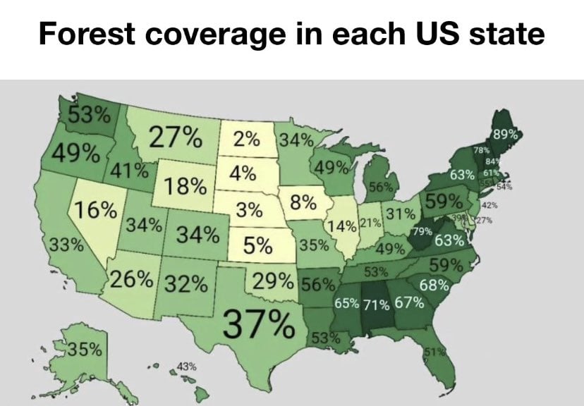
The 21% for Indiana is a little deceptive, because the northern half of the state is not very wooded at all, but the further south from Indianapolis you get, the more forested it gets. You can see it on this satellite map.
The glaciers pushed all the land in the south upward and made it very hilly, which is good tree country. As for the north, it's not because forests were clear cut. It's actually for a worse reason. The north used to be part of one of the world's biggest wetlands, the Grand Kankakee Marsh. It's been almost entirely drained for farmland.
https://www.southbendtribune.com/story/opinion/2016/01/02/andrea-neal-draining-of-kankakee-basin-destroyed-indiana-habita/46557981/
I guess I know the tree cover isn’t equally distributed, but it’s not necessarily my first thought, either. Pretty human mistake.
Thanks for the interesting and informative comment. I had no idea Indiana was like that. However, I did know that Ohio is similar because I’ve done research on Hocking Hills, and one of the things I read also talked about the park being outside the range of glacial erosion and how, in general, the more southerly areas represent ancient geology.
Hocking Hills is a lovely, if heavily visited, state park in Ohio.