14

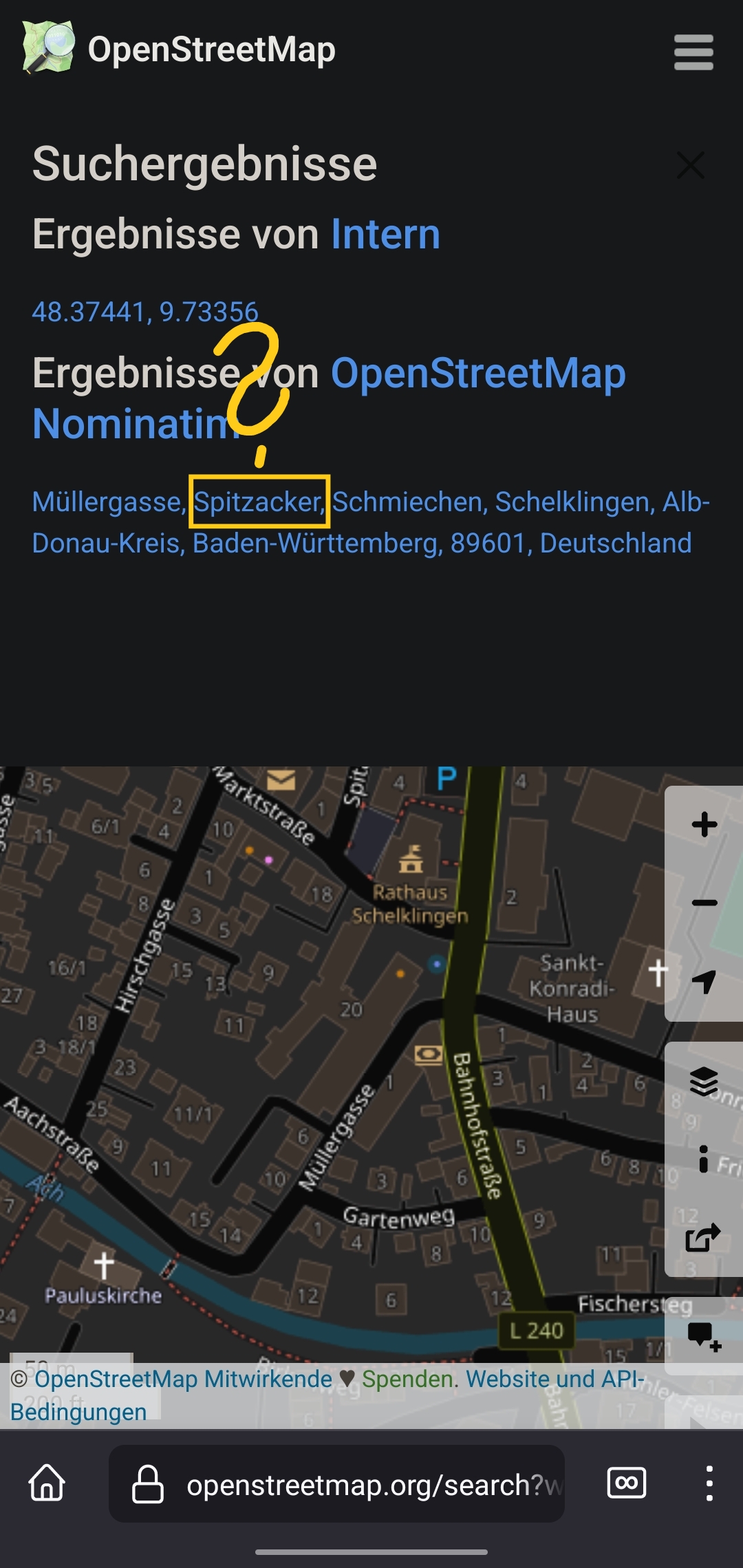
I am a regular Osmand user, but I don't know much about how OSM works in detail. I noticed that in some services that use OSM, addresses appear like in this screenshot.

This second part of the address often has interesting names that I've never heard even for places I know well.

To me it looks like the name of a Gemarkung or something similar.

  • What's the correct term for this part of an address?
  • Where is this data derived from?
  • Is it possible to show a map with the borders of these Gemarkungen (or whatever it is called)?

Also glad if someone can point me to the docs where I can read about this. I browsed the wiki but couldn't find what I was looking for.

Also interested about the correct terms for the other parts of the addresses.

Thanks!

top 4 comments
sorted by: hot top controversial new old
[-] barttier@feddit.de 3 points 1 year ago

Is a Gemarkung part of the adress when you have an actual adress like the streetname? Since Schmiechen is a part of the town Schelklingen and Müllergasse being a street might be the next smaller part of the adress I could not imagine that this is the position for the Gemarkung. But I couldn't figure out what might be between street and part of town. So I searched Spitzacker around Schelklingen and found a page stating it is a "Weiler". A Weiler is smaller than a Village, usually just a few buildings next to each other and without an own Administration. My guess would be, that osm mentions Spitzacker, because there was said Weiler and as Schmiechen grew it just became a part of Schmiechen. So while there is no actual Spitzacker anymore osm still refers to the historical area because the building might still stand. As of what part of the adress this might be: I don't think it is a part of the adress. I think osm takes its information from the local cadastral office and they provided all informations including historic areas. The cadastral office is also your goto adress to get docs about areas. In german its called Katasteramt and should be in Schelklingen.

[-] wmrch@lemmy.world 2 points 1 year ago

I have to add that the example shown in the screenshot is a random location so I'm not familiar with that village.

But that highlighted portion is not part of the postal address. And it's not listed under enclosing features (so no Verwaltungsgrenze, Bezirksgrenze or similar).

I agree it seems to be something historical but I see it in lots of locations and I think it's odd to include historic names in the address query by default, isn't it?

[-] thisfro@slrpnk.net 2 points 1 year ago

Not sure about osmand, but when you secondary click on a location on openstreetmap.org, you can select "query features" and see the "enclosing features. Maybe that helps?

Screenshot_20230813-225841_Bromite

[-] wmrch@lemmy.world 2 points 1 year ago

Unfortunately that second part does not show up in enclosing features.

this post was submitted on 13 Aug 2023
14 points (100.0% liked)

OpenStreetMap community

3690 readers
20 users here now

Everything #OpenStreetMap related is welcome: software releases, showing of your work, questions about how to tag something, as long as it has to do with OpenStreetMap or OpenStreetMap-related software.

OpenStreetMap is a map of the world, created by people like you and free to use under an open license.

Join OpenStreetMap and start mapping: https://www.openstreetmap.org.

There are many communication channels about OSM, many organized around a certain country or region. Discover them on https://openstreetmap.community

https://mapcomplete.osm.be is an easy-to-use website to view, edit and add points (such as shops, restaurants and others)

https://learnosm.org/en/ has a lot of information for beginners too.

founded 4 years ago
MODERATORS