this post was submitted on 27 Nov 2023
919 points (98.7% liked)
Funny: Home of the Haha
9003 readers
13 users here now
Welcome to /c/funny, a place for all your humorous and amusing content.
Looking for mods! Send an application to Stamets!
Our Rules:
-
Keep it civil. We're all people here. Be respectful to one another.
-
No sexism, racism, homophobia, transphobia or any other flavor of bigotry. I should not need to explain this one.
-
Try not to repost anything posted within the past month. Beyond that, go for it. Not everyone is on every site all the time.
Other Communities:
-
/c/TenForward@lemmy.world - Star Trek chat, memes and shitposts
-
/c/Memes@lemmy.world - General memes
founded 2 years ago
MODERATORS
you are viewing a single comment's thread
view the rest of the comments
view the rest of the comments
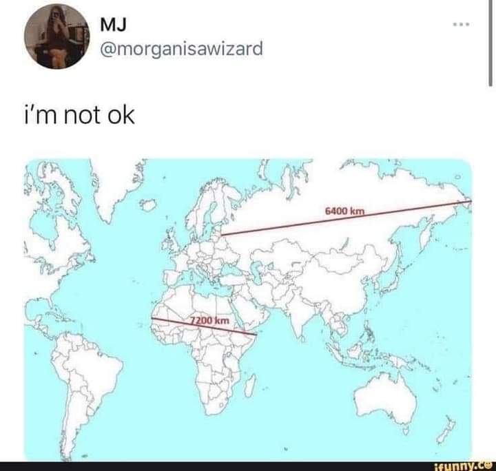
This is true. There are some projections that show area more accurately, or shape of landmasses, etc.
For example:
Many map projections do one thing well at the cost of sacrificing others. For example, the popular Mercator projection (which you'll see in many US schools and textbooks) is well suited for marine navigation but is exceptionally distorted the closer you get to the poles.
I kinda like how the Kavrayskiy VII projection looks. It appears to preserve both the area and the shape fairly well.
this kind of projection is my favourite, it just looks like a map that belongs on a wall
Which makes perfect sense for its use case - navigating from Belgium, Portugal and Spain to Africa, India and Central and South America.