Map Enthusiasts

3940 readers
200 users here now

For the map enthused!

Rules:

founded 2 years ago
MODERATORS
1


Hi folks! There hasn't been any misbehavior in this community, nor to be frank do I expect any, but it's good to have redundancy, cover more time zones, etc... in case of spambots and the like. I'm looking to add a couple more mods!

I don't have many metrics by which to choose fellow mods (such as the age of the account) so all you need to apply and get picked is to be active in this community (which means contribute posts and/or comments... the more quality contributions you've made the more likely you're to get picked). I'm CET, btw.

If you want to guard this community and help it stay a cozy place, apply here in the comments to become a mod. Feel free to add any additional reason why you think you should be picked! Are you a geographer? ~~Are you power hungry?~~ Are you ~~glued to your computer~~ an internet enthusiast? Apply now!

Applications will be open for a while until I pick a couple of peeps.

2
 
 
3


Please excuse the quality

4
 
 
5


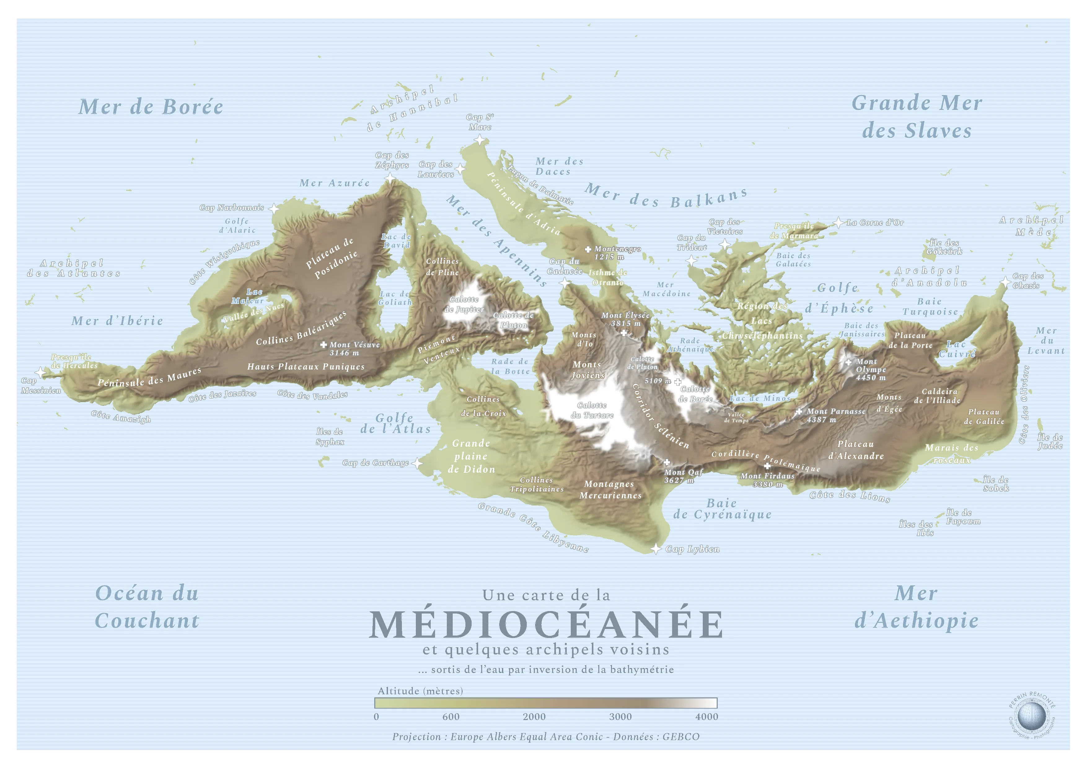
This is a map made by French cartograph Perrin Remonté:

Funny Sunday map interlude with a special map: it shows an imaginary continent hidden in the hollow of the Mediterranean, a name meaning “[the sea] in the middle of the lands”. This hidden continent is naturally “the land in the middle of the seas”, the Mediocean! The lands become seas and vice versa.

The black, inhospitable, cold and dark abysses become all white, covered with ice caps and beaten by high-altitude blizzards, like the Tartarus or Boreas caps which exceed 5000 meters in altitude, formerly 5000 meters deep while Mount Parnassus, Mount Olympus, Mount Qaf - real and legendary mountains - culminate at several thousand meters above sea level and still inspire beliefs and respect in these humans who look at them, fear them and admire them from the plains.

Sobek, Minos, Alexander, Alaric, Hannibal: the Gods, Kings and Queens rushed to give their names to these mountains, plateaus, seas, hills and coasts that emerged from the earth! It must be said that the Mediterranean is full of myths and legends, empires made and unmade, marvels of architecture or literature: the Caldera of the Iliad, the Peninsula of Hercules and the Bay of Galatea will be able to testify to this.


The map simply uses bathymetric data that I reversed, the rest is the result of intense internet research to find the best names. I am not Mediterranean for a penny, I have seen this sea once in my life but I tried to do it justice as best I could, it is a sacred piece of history and geography!

My other fictional maps are here!

6
 
 
7


Wyandotte County is home of Kansas City, KS (part of the Kansas City metro area). The local community college put out this information. Both pages can be found here.

8


Note! "Open source" here refers to the intelligence definition, not the software definition. It's analysis of maps from open sources. Hence open source, hence cartography. Although I guess you could be using open source software on the maps, too.

9
 
 
10
 
 
11
 
 
12
 
 
13


...and it looks awful

14


15


Created using QGIS and publicly available data in 2023.

16
 
 
17
 
 
18


I have a clear globe that i would like to project to a flat map. Any common projection should work, since computer programs exist for converting map projections. Where should i start?

A couple of details: First, my "globe" is an empty plastic Christmas tree ornament, so it can be hung from a string at one end but it doesn't have a stand like a normal globe does.

Second, this is a worldbuilding thing. My globe does not represent any real planet or similar body, which is why i need to make a new map from the globe instead of finding an existing one.

EDIT: To be clear, i know about projections already. I'm not worried about picking a projection. What i'm asking about is the process is for taking a physical globe and projecting that globe's surface onto a flat rectangle. I don't know how to turn an imaginary cylinder or cone sitting on my globe into a tangible physical or digital map. I don't have the means to cut up and unfold my globe until it's flat. What is the actual process for making a map from a globe, for any projection? I know this isn't how maps are traditionally made, but surely there must be a good way to do this.

19
20


I don’t know what to do with this information

21
22
 
 
23
 
 
24
 
 
25
view more: next ›