
What’s going on in that one area in Montana?
A place to discuss problems of car centric infrastructure or how it hurts us all. Let's explore the bad world of Cars!
1. Be Civil
You may not agree on ideas, but please do not be needlessly rude or insulting to other people in this community.
2. No hate speech
Don't discriminate or disparage people on the basis of sex, gender, race, ethnicity, nationality, religion, or sexuality.
3. Don't harass people
Don't follow people you disagree with into multiple threads or into PMs to insult, disparage, or otherwise attack them. And certainly don't doxx any non-public figures.
4. Stay on topic
This community is about cars, their externalities in society, car-dependency, and solutions to these.
5. No reposts
Do not repost content that has already been posted in this community.
Moderator discretion will be used to judge reports with regard to the above rules.
In the absence of a flair system on lemmy yet, let’s try to make it easier to scan through posts by type in here by using tags:
What’s going on in that one area in Montana?
I'm wondering that too. Just a guess, low population density with lots of farmers 'working from home' since they live on their farm.
Those two counties are Petroleum County, with a population of about 500, and Garfield County with a population of about 1,100. Both counties have a single town with about a quarter of the population.
This means a majority of the population live in the country, and likely work the lands they live on. This means no commute to work, which is what was measured.
This is a flaw in the methodology. Rurual Montana is not a bastion of urban planning. It is a mistake to look at travel to work exclusively. People need to travel to many destinations. And those living in those two counties probably use cars for everything else.
What the hell, Garfield county is about the quarter size of my country (the Netherlands, but only has 0,007% of the population. That's mind boggling to me
I wouldnt say it is a flaw, really. The data in general is a good approximation of auto dependence. And any researcher who isn't an idiot will see the same thing you did and simply discard the data in these counties as obvious outliers. Sure, we can imagine a more accurate metric for measuring auto dependency for the purposes of creating a very nice map for public consumption. But it your purpose is simply to conduct some statistical analysis, I don't think this dataset is bad - or at least not a bad start.
They don''t go to work. Farmers don't travel for work but it's likely low survey response. Very low population density there(1-10/mi)
You aren't getting anywhere in Montana without a car
Horses, atvs.
low population density means high variance in stats.
always expect the highest and lowest stats to come from those areas.
But it’s probably farmers who live on their farm or something.
What’s going on in that one area in Montana?
Nothing.
I drove though there once. Hours of seeing nothing but road.
Also, note the scale. It starts at 50% reliance.
A portio of that area I know is full of retirees who relocated to escape the woke coasts. (Speaking anecdotally of extended family that relocated to that zone for a community of old conservatives.) So I wonder if retirees are counted.
The area in Arizona thats a little lighter may also be a shade of that too. Snowbirds might be skewing it with people who just plain don't commute.
Swear to god, every heat map of the US highlights how much of a shit hole the Mississippi delta must be.
What is supposed to be surprising about this?
Everywhere I have lived, and everyone I have ever met had to take a car.
There are like maybe 15 places in the US with a functioning public transportation system.
Jobs are downtown but nobody make enough money to live downtown. Last time I tried it would have been > 75% my wages in rent only just to live in shit hole. I literally would not be able to feed myself.
The map actually does a good job of highlighting how population dense places exist without a lot of cars per person. New York and San Francisco are both shown and have green or yellow patches. Mass transit works so damn good but, like election maps, the actual region highlighted is empty space with a few people all doing the same things.
The real alternative to cars isn't public transit; it's walking and biking (with zoning density that facilitates that). Public transit is a 'nice to have' layer built on top afterward.
You're not going to live your life within biking distance.
And I say that as someone who's lived their entire life without owning a car, in one of the most densely-populated areas of Germany.
Public transit is an absolutely essential part of life, not a "nice to have".
Even in the most walkable of all cities, you're going to want to get to a lake for swimming, meet friends who live two towns over, transit to the airport, or simply have a reliable option to commute during a thunderstorm or when it's freezing.
Not everybody lives in the US and in a lot of countries being able to go to work without a car is normal.
This is a map of the us
Four out of the top nine counties are in NYC. Once again a common W for Manhattan, Queens, Brooklyn, and the Bronx (not you Staten Island, you suck)
Staten Island doesn't have the subway infrastructure that other boroughs have. The one line it does have does has relatively high usage. Maybe it's wise to expand it?
Staten’s a bunch of republicans. They aren’t gonna pay for anything that lets the rabble in.
Are there maps like this for other part of the world? I'd imagine Europe has a much lower rate of car commuting.
In comparison to the US yeah probably but still overall pretty high would be my assumption.
I found this picture showing the whole world.
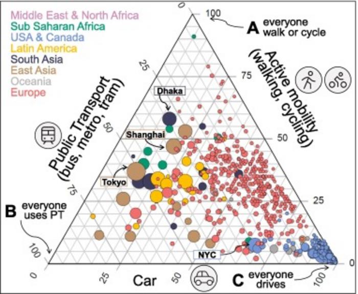
That is an abomination of data vis, good god
Yes it takes some time to decode, but it has lots of info.
It would be nice to somehow compare distances, time and population density as well.
Americans drive a lot, but they don't actually drive very far for work, whereas in Europe it's rather common to work in a different city than where you live. Asia has the highest population density and this benefits them both in finding local work and building public transport.
Yeah, this is one of the reasons why I only want to live in the NYC area of the US. Just take the train or bus, don't worry about it.
America is essentially a third world country with just a handful of developed metropolitan areas
And those few developed areas havnt meaningfully evolved or improved in decades and especially compared to the infrastructure developments seen in asia or Europe
I've lived in some of the counties in the south under 100% reliance and let me assure you outside of the major cities many are only under 100% due to crippling poverty. I can't tell you how many people I've know in my life thay have had to walk 2 hrs one way to a shitty low paying job at a gas station or dollar general.
A living nightmare
I think that's inflated. Many will say they depend on it without even having tried the local public transport, if available.
It's greatly inflated by virtue of doing it by county instead, mingling major transit routes with fully rural areas.
But even that aside I strongly agree. Cook county would be under 50 if people were more willing to take the train
Conclusion: the Gulf Coast makes Americans crave cars.
The lack of sufficient population density to support public transit makes Americans crave cars. Population density is low because the US has the space, and the areas that are dense are stupidly expensive.
I'd love to take a bus or light rail to work, but instead I end up having a saily commuteof over 100 miles round trip. In the city where I work, a 600sft studio apartment would cost an extra 30 grand a year versus my 3 bed, 2 bath place 50-ish miles away.
I feel like the only interesting bits are the yellow places that aren't big cities (with their subways or whatever), and that aren't places separated by water, where it makes sense that they travel across by ferry e.g. The few places where you'd expect cars to be the vast majority, but isn't. Those seem interesting to look closer into.
Viridis always brings peace to the soul
I knew it was bad,but this really shows some perspective. Holy shit dudes.
This is bonkers.
Does anyone know of similar maps for European or Asian countries? The only thing I’ve found so far it this report, but it doesn’t go into county-level detail.